優惠套餐

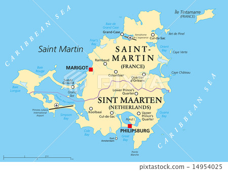
插圖素材: Saint Martin Island Political Map

素材編號 : 14954025 查看全部

Saint Martin Island Political Map[14954025],此圖庫插圖素材具有聖馬丁,地圖,島的關鍵詞。此插圖素材是Peter Hermes Furian / (No.362672)的作品。您可以購買圖像大小從影像尺寸從S至XL, 向量圖US$5.00以上的尺寸。註冊成為免費會員後,您可以下載帶有浮水印的圖片以確認畫質及使用收藏夾的服務。 查看全部

Saint Martin Island Political Map 14954025

Saint Martin Island Political Map

  • 1:1
  • 4:3
  • 4:5
    (8:10)
  • 3:2(6:4)
  • 自訂
    :

縮放

* 您可以拖曳以移動圖片

S
  • 640 x 454px
  • 22.6 x 16.0cm (72dpi)
JPG US$5.00
M
  • 2000 x 1420px
  • 16.9 x 12.0cm (300dpi)
JPG US$15.00
L
  • 4000 x 2841px
  • 33.9 x 24.1cm (300dpi)
JPG US$30.00
XL
  • 8445 x 6000px
  • 71.5 x 50.8cm (300dpi)
JPG US$50.00
V 包括向量圖 EPS US$35.00
Ex 追加擴展許可證 +US$30.00
合計:
[免費]編輯素材

只要使用免費編輯工具,
就算尚未購買素材亦可嘗試圖片的編輯、加工
詳細內容請點確認

插圖素材: Saint Martin Island Political Map的關鍵詞

描述/評論
Saint Martin Island Political Map. A Caribbean Island divided between the countries Saint-Martin (France) and Sint Maarten (The Netherlands). Map with capitals and important places. English labeling and scaling. Illustration.